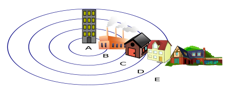
Five rings around one specific city
Ernest Burgess taught sociology at the University of Chicago, and the model he is best known for was built entirely from the city outside his own window. In "The Growth of the City: An Introduction to a Research Project," a chapter he contributed to the 1925 book The City alongside Robert E. Park and Roderick D. McKenzie, Burgess proposed that any expanding city organizes itself into five concentric rings. Zone I is the central business district, the Loop in Chicago's case, packed with banks, offices, and department stores. Zone II, the zone in transition, rings the business district with cheap rooming houses, small factories, and housing for recent immigrants, and it is expanding outward, encroaching on Zone III, the settled homes of factory workers who had already worked their way out of Zone II. Zone IV holds better apartments and single-family houses for the comfortably established, and Zone V, the commuter zone, is where the wealthiest residents live beyond the city line and travel in by rail.
Burgess called the whole diagram an "ideal construction," not a literal street map, and Chicago itself immediately complicates it: Lake Michigan sits on one side of the city, so the rings were never actual full circles even in the case study that produced them. The mechanism holding the model together is what Burgess termed invasion and succession, an idea borrowed from plant ecology: each inner zone is constantly pushing outward, converting the land use of the zone beyond it, the way an expanding factory district slowly displaces the working-class housing next to it. An earlier sociological account, Durkheim's collective effervescence, examined shared emotion during group rituals. Burgess's rings addressed urban growth, a different aspect of group life from the emotions produced during a ritual.
The ring that became a crime map
Clifford Shaw and Henry McKay, both based at Chicago's Institute for Juvenile Research, took Burgess's zones and mapped juvenile delinquency onto them for their 1942 book Juvenile Delinquency and Urban Areas. They found what the model would predict: delinquency rates were highest in the zone in transition and fell steadily with distance from the Loop. What they found next was the part that outlasted the map. Tracking delinquency rates across the same transitional neighborhoods over multiple decades, Shaw and McKay showed the high rates persisted even as the people living there changed entirely, from German and Irish immigrant families in the early records to Polish and Italian families later, and eventually to Black and Mexican American residents as the older groups moved outward into Zone III and beyond.
That turnover became their central argument. If a single ethnic group had been responsible for the delinquency, the high rates should have moved with that group as it relocated to better housing further out. Instead, the high rates stayed behind, attached to the zone itself. Shaw and McKay concluded the real drivers were structural features of the transitional zone, poverty, residential instability, and the physical deterioration that comes from a neighborhood being built for eventual demolition and factory conversion, a cluster of conditions they called social disorganization. It was a reformist argument for its time, aimed at redirecting blame away from whichever immigrant group happened to be living in the worst housing in a given decade. It also meant the concentric zone model, built to describe how a city's real estate market sorted itself, had become the organizing map for one of American criminology's founding theories.
Their 1942 book didn't stop at Chicago. Shaw and McKay reran the same zone-based mapping in at least eight other American cities, including Philadelphia, greater Boston, Cincinnati, Cleveland, Columbus, Richmond, Birmingham, and Denver, and found the same ecological pattern in each one: delinquency concentrated near the industrial and commercial core and thinned out toward the residential edges, regardless of which region of the country the city sat in or which immigrant groups had settled there. That cross-city replication is what elevated Burgess's Chicago-specific rings from a description of one city into a general claim about how American urban growth, crime, and neighborhood decline were connected, the version of the theory that later textbooks and later critics were actually responding to.
A rival wedge, and the economist who drew it
The concentric zone model's first serious challenger came from outside sociology entirely. Homer Hoyt was a land economist, and in a 1939 study for the Federal Housing Administration, The Structure and Growth of Residential Neighborhoods in American Cities, he analyzed rent and value data from 142 American cities and concluded Burgess had the shape wrong. Growth doesn't move outward in even rings, Hoyt argued; it moves in wedges that radiate from the center along transportation corridors, because a high-rent district, once established, keeps pulling new high-rent development in the same direction rather than spreading evenly in all directions. His sector model is taught as an alternative to Burgess's rings. Arno Peters's rival to the Mercator projection was also promoted against an established diagram, but its equal-area trade-off concerns map projection, not patterns of urban growth.
The same economist had a documented history that rarely makes it into that classroom comparison. Six years before the sector model, in his 1933 book One Hundred Years of Land Values in Chicago, Hoyt published an explicit ranking of ethnic and racial groups "with respect to their beneficial effect upon land values," running from English, German, Scottish, Irish, and Scandinavian residents at the top, through Northern Italian, Czechoslovakian, Polish, Lithuanian, and Greek residents, down through what the text called "Russian Jews of the lower class" and South Italian residents, to "Negroes and Mexicans" at the bottom. Hoyt went on to become the FHA's chief economist and, working with Frederick Babcock, helped write the agency's Underwriting Manual, which explicitly recommended racially restrictive covenants as a way to protect a neighborhood's "favorable" rating. Those ratings became the basis for the federal redlining maps that shaped American mortgage lending for decades.
A 2025 paper asks if the whole finding was circular
A 2025 paper in Criminal Justice Review by criminologists Shannon Linning and John Eck reopens the question Shaw and McKay thought they had settled. Their argument: one network of Chicago-connected academics studied why certain neighborhoods had high crime and concluded it was structural, poverty, ethnic heterogeneity, residential turnover. A separate but overlapping network of real estate professionals and federal housing officials, including economists working in Hoyt's tradition, spent the same decades actively producing those exact structural conditions through redlining, restrictive covenants, and disinvestment. Linning and Eck argue the two networks were connected closely enough that the "structural factors" community criminologists kept finding may not have been an independent cause of crime at all, but a downstream effect of real estate practice, which means the correlation the field built on may be, in their word, spurious: a self-fulfilling prophecy where the same forces that impoverished a neighborhood also produced the data confirming that impoverished neighborhoods were dangerous.
That argument doesn't erase what Burgess drew or what Shaw and McKay found; the zone in transition, and the finding that its high crime rates outlasted every ethnic group that lived in it, remains one of the better-supported observations in the model's history. Walter Christaller's settlement hierarchy also received support from Iowa field data. That 1967 finding concerned town spacing and market thresholds, not the causes of delinquency. What the 2025 paper adds is a reminder that the map, the crime statistics laid over it, and the housing policy that shaped the neighborhoods underneath were never three separate, independent things.