.jpg)
The six master horizons, and why most profiles don't show all of them
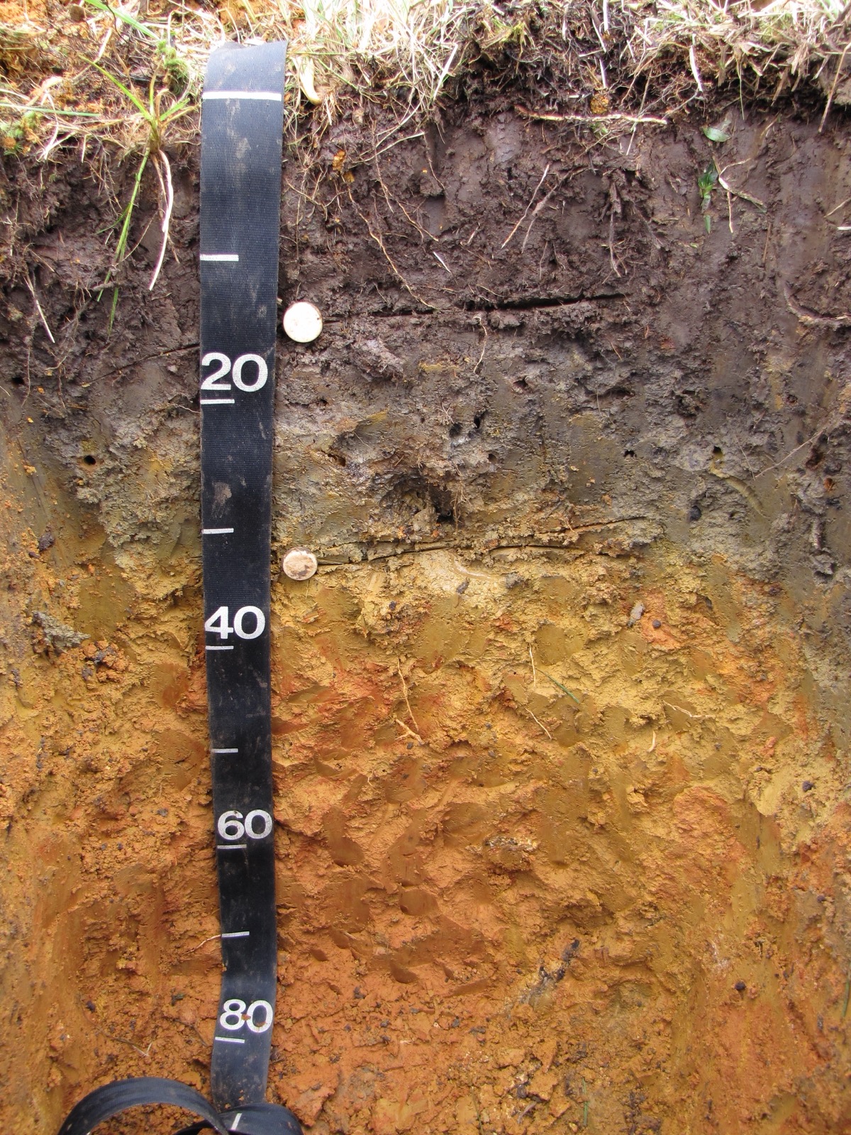
A soil profile isn't a uniform block of brown; it's a stack of horizontal layers called horizons, each shaped by a different mix of chemical and biological processes acting on the same starting material. The USDA's Natural Resources Conservation Service formalizes the system in its 2017 Soil Survey Manual, assigning a capital letter to each master horizon, O, A, E, B, C and R, read from the surface downward, though the manual itself is clear that no single profile is required to contain all six.
The O horizon sits on top, built from decomposing leaves, twigs and other organic litter; it's frequently absent from farmland and suburban lawns, since plowing and grading routinely strip it away. Below it is the A horizon, the true topsoil, a mix of decomposed organic matter and mineral grains that's usually darker and more biologically active than anything beneath it. Soil also provides habitat: millipedes push through narrow channels underground, while trapdoor spiders disguise their burrow lids with soil and litter. Those examples do not identify the soil horizon the animals occupy. The E horizon, when present, sits just below the A and forms through eluviation, water percolating downward and washing clay, iron and organic compounds out of the layer, leaving it pale, ashy or bleached; it's absent from a large share of the world's soils, especially in warmer, less-leached climates. The B horizon is illuviation's mirror image, a zone where material washed out of the A and E horizons accumulates, often turning it a deeper red, orange or yellow from iron-oxide buildup than the layers above. Below that sits the C horizon, weathered parent material that hasn't yet turned into true soil, and finally the R horizon, unweathered bedrock, which by the Soil Survey Manual's own definition isn't classified as soil at all.
Vasily Dokuchaev: the scientist who insisted soil was alive
The horizon framework is barely 150 years old. Vasily Dokuchaev, a Russian geologist studying the fertile black soils of the Russian steppe after a severe regional drought and famine pushed the government to fund an investigation into why the region's celebrated farmland kept failing, introduced the term "horizon" in his 1871 university thesis and built it into a full theory in his 1883 monograph Russian Chernozem. Before Dokuchaev, most European geologists treated soil as little more than weathered rock, a passive byproduct of erosion with no biology or history of its own.
Dokuchaev argued the opposite: soil was a distinct natural body with its own genesis, produced by the interaction of parent rock, climate, living organisms, terrain and time, and its layered structure recorded that history much as tree rings record a forest's. He had already identified all five of those factors; what Swiss-born soil scientist Hans Jenny added, in his influential 1941 book Factors of Soil Formation, was a way to turn Dokuchaev's descriptive list into a quantitative equation, S = f(cl, o, r, p, t), giving soil scientists something they could actually test against real profiles, not merely describe.
Does it really take 500 years to grow an inch of topsoil?
American soil-conservation education has repeated one number for decades: it takes roughly 500 years for nature to build a single inch of topsoil, a figure that shows up in USDA-affiliated teaching materials and countless conservation-district factsheets, usually deployed to argue erosion is essentially irreversible on a human timescale. That number is a long-run average, and the real chronosequence data behind it tells a more useful story than the average alone does.
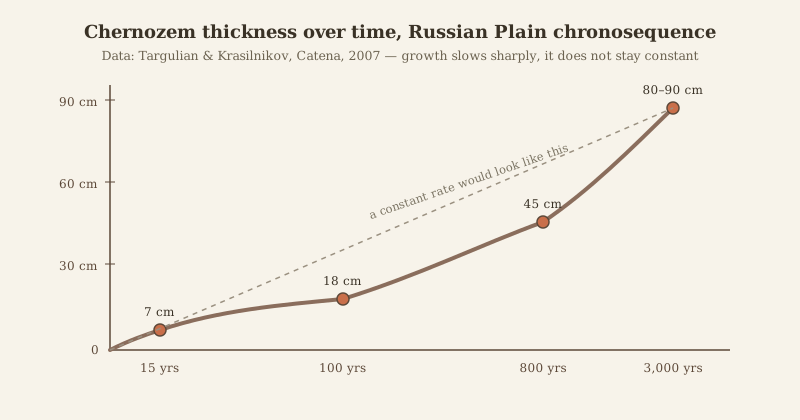
Viktor Targulian and Pavel Krasilnikov, publishing in the journal Catena in 2007, compiled dated soil-formation measurements from chronosequences, sequences of soils of different known ages developing on similar parent material, including sites on the Russian Plain near where Dokuchaev did his original chernozem fieldwork. Their data show profile thickness growing fastest early on and slowing sharply afterward: roughly 7 cm of accumulated soil after 15 years, 18 cm after 100 years, 45 cm after 800 years, and only 80 to 90 cm after 2,000 to 4,000 years. A young, freshly exposed subsoil can add its first inch in well under a century; a mature profile that's already tens of centimeters deep might take many centuries to add its next one, because as a soil deepens, the roots, worms, insects and downward-percolating water that actually drive horizon formation have to work through more material to reach and alter the next layer. The oft-cited 500-year figure flattens an exponentially decelerating curve into a single static rate. It describes the far end of that curve, an aging, already-established soil, not the pace at which freshly exposed ground actually starts building itself back up.
When soil horizons become murder evidence: the Camarena case
A horizon's color, texture and mineral makeup are tied to a specific place, which is why soil can double as physical evidence. FBI Special Agent Ronald Rawalt, a forensic geologist working out of the Bureau's Washington laboratory, applied that logic to the investigation into the February 1985 kidnapping and murder of DEA agent Enrique Camarena in Guadalajara, Mexico. Mexican federal police said they had located Camarena's buried body at a ranch belonging to a Guadalajara drug trafficker. FBI agent Jack Dillon, posing as a DEA agent inside the Guadalajara morgue, collected about a teaspoon of soil from Camarena's skin and clothing; back in Washington, Rawalt found the sample was wet and dark, stuck together by adipose tissue that had leached from the decomposing body, so FBI chemists first had to burn the organic material off in an oxygen plasma-reduction unit before Rawalt could read the mineral's true color.
Once cleaned, the sample's color and mineral content didn't match soil taken from the ranch, which the FBI Law Enforcement Bulletin's 1989 account of the case, written by agent Michael Malone, describes as volcanic but coarser-grained and drawn from a different eruptive source. Rawalt traced an unusual pink-glass mineral in the sample, using an unpublished geology dissertation on the region and a Smithsonian volcanologist's confirmation, to a specific caldera event confined to Bosques de la Primavera, a state park outside Guadalajara. He and agent Malone flew to Mexico, set up a field microscope on a pickup-truck tailgate, and within days located a car sealed behind a freshly built adobe wall near the park's southern edge, its interior carrying blood and hair that matched samples taken from Camarena's body, evidence that the ranch story had been staged. Writer John McPhee documented Rawalt's investigation in a 1996 New Yorker article, "The Gravel Page"; forensic evidence of various kinds, soil analysis among it, eventually contributed to seven convictions among the eight defendants tried in the United States on charges that included murder.
Twelve orders, one map: how horizons combine into a global system
Individual horizons combine into complete profiles, and the USDA groups those profiles into twelve soil orders that classify essentially all the world's ice-free land. Entisols, young soils with barely any horizon development at all, are the most extensive order, covering roughly 18 percent of ice-free land, mostly recent floodplains, dunes and steep slopes where erosion or deposition outpaces horizon formation. Aridisols, desert soils with weak organic layers and often a subsurface accumulation of calcium carbonate or salts, cover about 12 percent. Their classification depends on soil moisture and diagnostic features of the profile. Annual precipitation alone is insufficient to identify the soil order. The climatic definition of a desert answers a different question: low precipitation makes Antarctica the planet's largest desert, ahead of the Sahara. Mollisols, the dark, organic-rich soils typified by Dokuchaev's own chernozem, which US Soil Taxonomy classifies among the Udoll and Ustoll suborders, cover only about 7 percent of ice-free land globally but include most of the world's major grain belts: the North American prairies, the Ukrainian and southern Russian steppe, and Argentina's Pampas.
At the opposite extreme sit Gelisols, soils underlain by permafrost, where horizon development is disrupted by repeated freeze-thaw cycling that physically churns the profile, a process called cryoturbation, rather than by the steady chemical weathering that builds an ordinary B horizon. Soil horizons develop through biological activity, weathering and the movement of materials within a profile. A stalagmite growing thin mineral layers on a cave floor also preserves a layered history, but its layers form through mineral precipitation, a different process from pedogenesis.